
Select Category
_0x200.jpg)
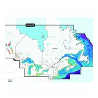
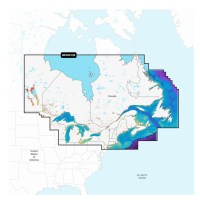
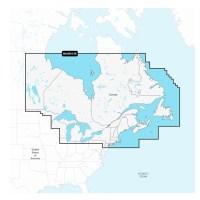
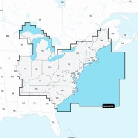
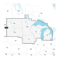
Navionics+ 010-C146630 Canada, East & Great Lakes Chart - 010-C1466-30 - 155-010C146630F1
Navionics+ Canada, East & Great Lakes -Lakes, Rivers and Coastal Marine Chart. Includes a one-year subscription to Daily Updates and advanced features. After a year, renew at a discounted priceVisit Navionics website for full feature list, coverage details and compatibility of Navionics+ content and features with your GPS chartplotter.**NOT COMPATIBLE with GARMIN GPS chartplotters*
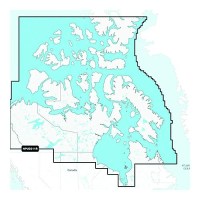
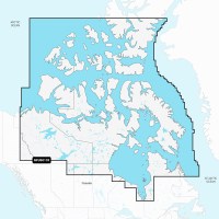
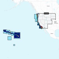
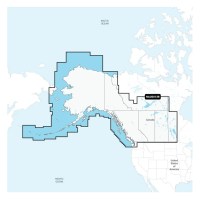
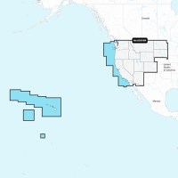
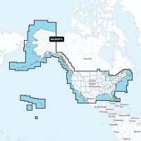
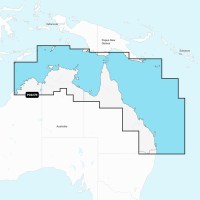
Navionics+ 010-C146230 Canada North Chart - 010-C1462-30 - 155-010C146230F1
Navionics+ Canada, Canada North-Lakes, Rivers and Coastal Marine Chart. Includes a one-year subscription to Daily Updates and advanced features. After a year, renew at a discounted priceVisit Navionics website for full feature list, coverage details and compatibility of Navionics+ content and features with your GPS chartplotter.**NOT COMPATIBLE with GARMIN GPS chartplotters*
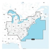
Navionics Platinum+ NPUS012R - Canada, East & Great Lakes
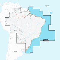
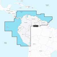
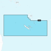
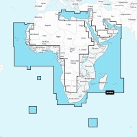
Navionics Platinum+ NPSA011R - South America North
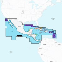
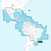
Navionics Platinum+ NPSA010R - Central America & Caribbean

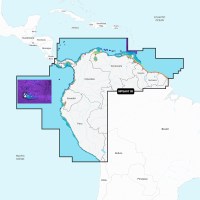
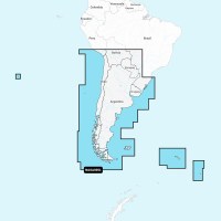
Navionics Platinum+ NPSA005L - Chile, Argentina & Easter Island
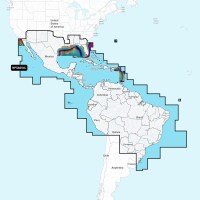
Navionics Platinum+ NPSA004L - Mexico, Caribbean to Brazil
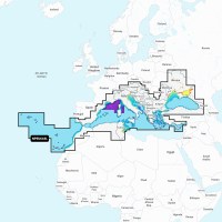
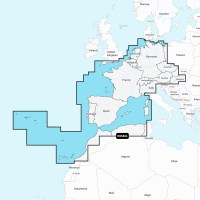
Navionics NPEU643L - Mediterranean & Black Sea - Navionics Platinum+

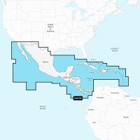
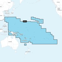
Navionics NASA010R - Central America & Caribbean - Navionics+
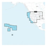
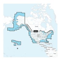
Navionics 010C137140 Platinum+ Cartography, U.S. West - 010-C1371-40 - 155-010C137140F1
THE NAVIONICS SUBSCRIPTION: A one-year subscription to Daily Updates and advanced features is included when you purchase any new Navionics Platinum+ mapping solution. After a year, you can renew at a discounted price CHARTS AND UPDATES:Nautical Chart - Comprehensive charts are derived from multiple official, government and private sources, displayed in a familiar look and feelSonarChart HD Bathymetry - Innovative 1' (0.5 m) bathymetry charts are created by using Navionics proprietary systems that augment existing content with sonar data contributed by the boating communityCommunity Edits - Get useful local knowledge from edits made by users of the Navionics Boating app on your compatible smart device.Daily Updates - Up to 5,000 daily updates to our charts give you the most accurate, most current Navionics data availableInland Content: 42,000+ lakes (varies by coverage area) ADVANCED FEATURES:Dock-to-dock Route Guidance - Start your trip with a suggested pathSonarChart Live Mapping Feature - Watch new HD depth maps develop in real time as your boat moves through the waterAdvanced Map Options - Customize your view to focus on the details that matter mostPlotter Sync - Transfer routes and markers, update chart layers and more - between your compatible chartplotter and the Boating app OVERLAYS:Relief Shading - Get an easy-to-interpret, clearer view of bottom structure. Check coverageSatellite Imagery with SonarChart Shading Overlay - Experience an enhanced awareness above and below the waterline. Check coverageSonar Imagery - View bottom hardness clearly and in contrasting color PLATINUM+ ADDITIONAL VIEWING OPTIONS:3D View - Adjust the perspective of your chart view to highlight key features and enhance awarenessAerial Photos - Get a better sense of your surroundingsVisit Navionics website for full feature list, coverage details and compatibility of Platinum+ content and features with your GPS chartplotter.**NOT COMPATIBLE with GARMIN GPS chartplotters**
Navionics 010C137130 Navionics+ Cartography, U.S. West - 010-C1371-30 - 155-010C137130F1
THE NAVIONICS SUBSCRIPTION: A one-year subscription to Daily Updates and advanced features is included when you purchase any Navionics+ mapping solution. After a year, you can renew at a discounted price.CHARTS AND UPDATES:Nautical Chart - Comprehensive charts are derived from multiple official, government and private sources, displayed in a familiar look and feel.SonarChart HD Bathymetry - Innovative 1' (0.5 m) bathymetry charts are created by using Navionics proprietary systems that augment existing content with sonar data contributed by the boating community.Community Edits - Get useful local knowledge from edits made by users of the Navionics Boating app on your compatible smart device.Daily Updates - Up to 5,000 daily updates to our charts give you the most accurate, most current data availableInland Content: 42,000+ lakes (varies by coverage area)ADVANCED FEATURES:Dock-to-dock Route Guidance - Start your trip with a suggested dock-to-dock route.Advanced Map Options - Customize your view to focus on the details that matter most.Plotter Sync - Transfer routes and markers, update chart layers and more - between your compatible chartplotter and the Boating app.SonarChart Live Mapping Feature - Watch new HD depth maps develop in real time as your boat moves through the water. Visit Navionics website for full feature list, coverage details and compatibility of Navionics+ content and features with your GPS chartplotter. **NOT COMPATIBLE with GARMIN GPS chartplotters**
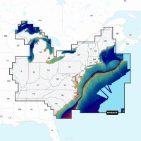
Navionics 010C137040 Platinum+ Cartography, U.S. East - 010-C1370-40 - 155-010C137040F1
THE NAVIONICS SUBSCRIPTION: A one-year subscription to Daily Updates and advanced features is included when you purchase any new Navionics Platinum+ mapping solution. After a year, you can renew at a discounted price CHARTS AND UPDATES:Nautical Chart - Comprehensive charts are derived from multiple official, government and private sources, displayed in a familiar look and feelSonarChart HD Bathymetry - Innovative 1' (0.5 m) bathymetry charts are created by using Navionics proprietary systems that augment existing content with sonar data contributed by the boating communityCommunity Edits - Get useful local knowledge from edits made by users of the Navionics Boating app on your compatible smart device.Daily Updates - Up to 5,000 daily updates to our charts give you the most accurate, most current Navionics data availableInland Content: 42,000+ lakes (varies by coverage area) ADVANCED FEATURES:Dock-to-dock Route Guidance - Start your trip with a suggested pathSonarChart Live Mapping Feature - Watch new HD depth maps develop in real time as your boat moves through the waterAdvanced Map Options - Customize your view to focus on the details that matter mostPlotter Sync - Transfer routes and markers, update chart layers and more - between your compatible chartplotter and the Boating app OVERLAYS:Relief Shading - Get an easy-to-interpret, clearer view of bottom structure. Check coverageSatellite Imagery with SonarChart Shading Overlay - Experience an enhanced awareness above and below the waterline. Check coverageSonar Imagery - View bottom hardness clearly and in contrasting color PLATINUM+ ADDITIONAL VIEWING OPTIONS:3D View - Adjust the perspective of your chart view to highlight key features and enhance awarenessAerial Photos - Get a better sense of your surroundingsVisit Navionics website for full feature list, coverage details and compatibility of Platinum+ content and features with your GPS chartplotter.**NOT COMPATIBLE with GARMIN GPS chartplotters**
Navionics 010C137030 Navionics+ Cartography, U.S. East - 010-C1370-30 - 155-010C137030F1
THE NAVIONICS SUBSCRIPTION: A one-year subscription to Daily Updates and advanced features is included when you purchase any Navionics+ mapping solution. After a year, you can renew at a discounted price.CHARTS AND UPDATES:Nautical Chart - Comprehensive charts are derived from multiple official, government and private sources, displayed in a familiar look and feel.SonarChart HD Bathymetry - Innovative 1' (0.5 m) bathymetry charts are created by using Navionics proprietary systems that augment existing content with sonar data contributed by the boating community.Community Edits - Get useful local knowledge from edits made by users of the Navionics Boating app on your compatible smart device.Daily Updates - Up to 5,000 daily updates to our charts give you the most accurate, most current data availableInland Content: 42,000+ lakes (varies by coverage area)ADVANCED FEATURES:Dock-to-dock Route Guidance - Start your trip with a suggested dock-to-dock route.Advanced Map Options - Customize your view to focus on the details that matter most.Plotter Sync - Transfer routes and markers, update chart layers and more - between your compatible chartplotter and the Boating app.SonarChart Live Mapping Feature - Watch new HD depth maps develop in real time as your boat moves through the water. Visit Navionics website for full feature list, coverage details and compatibility of Navionics+ content and features with your GPS chartplotter. **NOT COMPATIBLE with GARMIN GPS chartplotters**
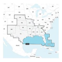
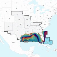
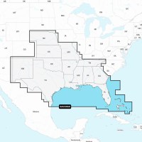
Navionics 010C136940 Platinum+ Cartography, U.S. South - 010-C1369-40 - 155-010C136940F1
THE NAVIONICS SUBSCRIPTION: A one-year subscription to Daily Updates and advanced features is included when you purchase any new Navionics Platinum+ mapping solution. After a year, you can renew at a discounted price CHARTS AND UPDATES:Nautical Chart - Comprehensive charts are derived from multiple official, government and private sources, displayed in a familiar look and feelSonarChart HD Bathymetry - Innovative 1' (0.5 m) bathymetry charts are created by using Navionics proprietary systems that augment existing content with sonar data contributed by the boating communityCommunity Edits - Get useful local knowledge from edits made by users of the Navionics Boating app on your compatible smart device.Daily Updates - Up to 5,000 daily updates to our charts give you the most accurate, most current Navionics data availableInland Content: 42,000+ lakes (varies by coverage area) ADVANCED FEATURES:Dock-to-dock Route Guidance - Start your trip with a suggested pathSonarChart Live Mapping Feature - Watch new HD depth maps develop in real time as your boat moves through the waterAdvanced Map Options - Customize your view to focus on the details that matter mostPlotter Sync - Transfer routes and markers, update chart layers and more - between your compatible chartplotter and the Boating app OVERLAYS:Relief Shading - Get an easy-to-interpret, clearer view of bottom structure. Check coverageSatellite Imagery with SonarChart Shading Overlay - Experience an enhanced awareness above and below the waterline. Check coverageSonar Imagery - View bottom hardness clearly and in contrasting color PLATINUM+ ADDITIONAL VIEWING OPTIONS:3D View - Adjust the perspective of your chart view to highlight key features and enhance awarenessAerial Photos - Get a better sense of your surroundingsVisit Navionics website for full feature list, coverage details and compatibility of Platinum+ content and features with your GPS chartplotter.**NOT COMPATIBLE with GARMIN GPS chartplotters**
Navionics 010C136930 Navionics+ Cartography, U.S. South - 010-C1369-30 - 155-010C136930F1
THE NAVIONICS SUBSCRIPTION: A one-year subscription to Daily Updates and advanced features is included when you purchase any Navionics+ mapping solution. After a year, you can renew at a discounted price.CHARTS AND UPDATES:Nautical Chart - Comprehensive charts are derived from multiple official, government and private sources, displayed in a familiar look and feel.SonarChart HD Bathymetry - Innovative 1' (0.5 m) bathymetry charts are created by using Navionics proprietary systems that augment existing content with sonar data contributed by the boating community.Community Edits - Get useful local knowledge from edits made by users of the Navionics Boating app on your compatible smart device.Daily Updates - Up to 5,000 daily updates to our charts give you the most accurate, most current data availableInland Content: 42,000+ lakes (varies by coverage area)ADVANCED FEATURES:Dock-to-dock Route Guidance - Start your trip with a suggested dock-to-dock route.Advanced Map Options - Customize your view to focus on the details that matter most.Plotter Sync - Transfer routes and markers, update chart layers and more - between your compatible chartplotter and the Boating app.SonarChart Live Mapping Feature - Watch new HD depth maps develop in real time as your boat moves through the water. Visit Navionics website for full feature list, coverage details and compatibility of Navionics+ content and features with your GPS chartplotter. **NOT COMPATIBLE with GARMIN GPS chartplotters**

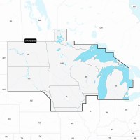
Navionics 010C136840 Platinum+ Cartography, U.S. North - 010-C1368-40 - 155-010C136840F1
THE NAVIONICS SUBSCRIPTION: A one-year subscription to Daily Updates and advanced features is included when you purchase any new Navionics Platinum+ mapping solution. After a year, you can renew at a discounted price CHARTS AND UPDATES:Nautical Chart - Comprehensive charts are derived from multiple official, government and private sources, displayed in a familiar look and feelSonarChart HD Bathymetry - Innovative 1' (0.5 m) bathymetry charts are created by using Navionics proprietary systems that augment existing content with sonar data contributed by the boating communityCommunity Edits - Get useful local knowledge from edits made by users of the Navionics Boating app on your compatible smart device.Daily Updates - Up to 5,000 daily updates to our charts give you the most accurate, most current Navionics data availableInland Content: 42,000+ lakes (varies by coverage area) ADVANCED FEATURES:Dock-to-dock Route Guidance - Start your trip with a suggested pathSonarChart Live Mapping Feature - Watch new HD depth maps develop in real time as your boat moves through the waterAdvanced Map Options - Customize your view to focus on the details that matter mostPlotter Sync - Transfer routes and markers, update chart layers and more - between your compatible chartplotter and the Boating app OVERLAYS:Relief Shading - Get an easy-to-interpret, clearer view of bottom structure. Check coverageSatellite Imagery with SonarChart Shading Overlay - Experience an enhanced awareness above and below the waterline. Check coverageSonar Imagery - View bottom hardness clearly and in contrasting color PLATINUM+ ADDITIONAL VIEWING OPTIONS:3D View - Adjust the perspective of your chart view to highlight key features and enhance awarenessAerial Photos - Get a better sense of your surroundingsVisit Navionics website for full feature list, coverage details and compatibility of Platinum+ content and features with your GPS chartplotter.**NOT COMPATIBLE with GARMIN GPS chartplotters**
Navionics 010C136830 Navionics+ Cartography, U.S. North - 010-C1368-30 - 155-010C136830F1
THE NAVIONICS SUBSCRIPTION: A one-year subscription to Daily Updates and advanced features is included when you purchase any Navionics+ mapping solution. After a year, you can renew at a discounted price.CHARTS AND UPDATES:Nautical Chart - Comprehensive charts are derived from multiple official, government and private sources, displayed in a familiar look and feel.SonarChart HD Bathymetry - Innovative 1' (0.5 m) bathymetry charts are created by using Navionics proprietary systems that augment existing content with sonar data contributed by the boating community.Community Edits - Get useful local knowledge from edits made by users of the Navionics Boating app on your compatible smart device.Daily Updates - Up to 5,000 daily updates to our charts give you the most accurate, most current data availableInland Content: 42,000+ lakes (varies by coverage area)ADVANCED FEATURES:Dock-to-dock Route Guidance - Start your trip with a suggested dock-to-dock route.Advanced Map Options - Customize your view to focus on the details that matter most.Plotter Sync - Transfer routes and markers, update chart layers and more - between your compatible chartplotter and the Boating app.SonarChart Live Mapping Feature - Watch new HD depth maps develop in real time as your boat moves through the water. Visit Navionics website for full feature list, coverage details and compatibility of Navionics+ content and features with your GPS chartplotter. **NOT COMPATIBLE with GARMIN GPS chartplotters**
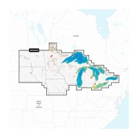
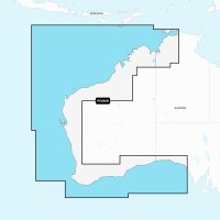
Navionics 010C136630 Navionics+ Cartography, U.S. & Coastal Canada - 010-C1366-30 - 155-010C136630F1
THE NAVIONICS SUBSCRIPTION: A one-year subscription to Daily Updates and advanced features is included when you purchase any Navionics+ mapping solution. After a year, you can renew at a discounted price.CHARTS AND UPDATES:Nautical Chart - Comprehensive charts are derived from multiple official, government and private sources, displayed in a familiar look and feel.SonarChart HD Bathymetry - Innovative 1' (0.5 m) bathymetry charts are created by using Navionics proprietary systems that augment existing content with sonar data contributed by the boating community.Community Edits - Get useful local knowledge from edits made by users of the Navionics Boating app on your compatible smart device.Daily Updates - Up to 5,000 daily updates to our charts give you the most accurate, most current data availableInland Content: 42,000+ lakes (varies by coverage area)ADVANCED FEATURES:Dock-to-dock Route Guidance - Start your trip with a suggested dock-to-dock route.Advanced Map Options - Customize your view to focus on the details that matter most.Plotter Sync - Transfer routes and markers, update chart layers and more - between your compatible chartplotter and the Boating app.SonarChart Live Mapping Feature - Watch new HD depth maps develop in real time as your boat moves through the water. Visit Navionics website for full feature list, coverage details and compatibility of Navionics+ content and features with your GPS chartplotter. **NOT COMPATIBLE with GARMIN GPS chartplotters**
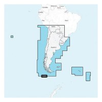
Navionics 010C136540 Platinum+ Cartography, Chile, Argentina & Easter Island - 010-C1365-40 - 155-010C136540F1
THE NAVIONICS SUBSCRIPTION: A one-year subscription to Daily Updates and advanced features is included when you purchase any new Navionics Platinum+ mapping solution. After a year, you can renew at a discounted price CHARTS AND UPDATES:Nautical Chart - Comprehensive charts are derived from multiple official, government and private sources, displayed in a familiar look and feelSonarChart HD Bathymetry - Innovative 1' (0.5 m) bathymetry charts are created by using Navionics proprietary systems that augment existing content with sonar data contributed by the boating communityCommunity Edits - Get useful local knowledge from edits made by users of the Navionics Boating app on your compatible smart device.Daily Updates - Up to 5,000 daily updates to our charts give you the most accurate, most current Navionics data availableInland Content: 42,000+ lakes (varies by coverage area) ADVANCED FEATURES:Dock-to-dock Route Guidance - Start your trip with a suggested pathSonarChart Live Mapping Feature - Watch new HD depth maps develop in real time as your boat moves through the waterAdvanced Map Options - Customize your view to focus on the details that matter mostPlotter Sync - Transfer routes and markers, update chart layers and more - between your compatible chartplotter and the Boating app OVERLAYS:Relief Shading - Get an easy-to-interpret, clearer view of bottom structure. Check coverageSatellite Imagery with SonarChart Shading Overlay - Experience an enhanced awareness above and below the waterline. Check coverageSonar Imagery - View bottom hardness clearly and in contrasting color PLATINUM+ ADDITIONAL VIEWING OPTIONS:3D View - Adjust the perspective of your chart view to highlight key features and enhance awarenessAerial Photos - Get a better sense of your surroundingsVisit Navionics website for full feature list, coverage details and compatibility of Platinum+ content and features with your GPS chartplotter.**NOT COMPATIBLE with GARMIN GPS chartplotters**
Navionics 010C136530 Navionics+ Cartography, Chile, Argentina & Easter Island - 010-C1365-30 - 155-010C136530F1
THE NAVIONICS SUBSCRIPTION: A one-year subscription to Daily Updates and advanced features is included when you purchase any Navionics+ mapping solution. After a year, you can renew at a discounted price.CHARTS AND UPDATES:Nautical Chart - Comprehensive charts are derived from multiple official, government and private sources, displayed in a familiar look and feel.SonarChart HD Bathymetry - Innovative 1' (0.5 m) bathymetry charts are created by using Navionics proprietary systems that augment existing content with sonar data contributed by the boating community.Community Edits - Get useful local knowledge from edits made by users of the Navionics Boating app on your compatible smart device.Daily Updates - Up to 5,000 daily updates to our charts give you the most accurate, most current data availableInland Content: 42,000+ lakes (varies by coverage area)ADVANCED FEATURES:Dock-to-dock Route Guidance - Start your trip with a suggested dock-to-dock route.Advanced Map Options - Customize your view to focus on the details that matter most.Plotter Sync - Transfer routes and markers, update chart layers and more - between your compatible chartplotter and the Boating app.SonarChart Live Mapping Feature - Watch new HD depth maps develop in real time as your boat moves through the water. Visit Navionics website for full feature list, coverage details and compatibility of Navionics+ content and features with your GPS chartplotter. **NOT COMPATIBLE with GARMIN GPS chartplotters**
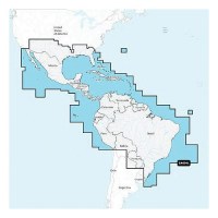
Navionics 010C136440 Platinum+ Cartography, Mexico, Caribbean To Brazil - 010-C1364-40 - 155-010C136440F1
THE NAVIONICS SUBSCRIPTION: A one-year subscription to Daily Updates and advanced features is included when you purchase any new Navionics Platinum+ mapping solution. After a year, you can renew at a discounted price CHARTS AND UPDATES:Nautical Chart - Comprehensive charts are derived from multiple official, government and private sources, displayed in a familiar look and feelSonarChart HD Bathymetry - Innovative 1' (0.5 m) bathymetry charts are created by using Navionics proprietary systems that augment existing content with sonar data contributed by the boating communityCommunity Edits - Get useful local knowledge from edits made by users of the Navionics Boating app on your compatible smart device.Daily Updates - Up to 5,000 daily updates to our charts give you the most accurate, most current Navionics data availableInland Content: 42,000+ lakes (varies by coverage area) ADVANCED FEATURES:Dock-to-dock Route Guidance - Start your trip with a suggested pathSonarChart Live Mapping Feature - Watch new HD depth maps develop in real time as your boat moves through the waterAdvanced Map Options - Customize your view to focus on the details that matter mostPlotter Sync - Transfer routes and markers, update chart layers and more - between your compatible chartplotter and the Boating app OVERLAYS:Relief Shading - Get an easy-to-interpret, clearer view of bottom structure. Check coverageSatellite Imagery with SonarChart Shading Overlay - Experience an enhanced awareness above and below the waterline. Check coverageSonar Imagery - View bottom hardness clearly and in contrasting color PLATINUM+ ADDITIONAL VIEWING OPTIONS:3D View - Adjust the perspective of your chart view to highlight key features and enhance awarenessAerial Photos - Get a better sense of your surroundingsVisit Navionics website for full feature list, coverage details and compatibility of Platinum+ content and features with your GPS chartplotter.**NOT COMPATIBLE with GARMIN GPS chartplotters**
Navionics 010C136430 Navionics+ Cartography, Mexico, Caribbean To Brazil - 010-C1364-30 - 155-010C136430F1
THE NAVIONICS SUBSCRIPTION: A one-year subscription to Daily Updates and advanced features is included when you purchase any Navionics+ mapping solution. After a year, you can renew at a discounted price.CHARTS AND UPDATES:Nautical Chart - Comprehensive charts are derived from multiple official, government and private sources, displayed in a familiar look and feel.SonarChart HD Bathymetry - Innovative 1' (0.5 m) bathymetry charts are created by using Navionics proprietary systems that augment existing content with sonar data contributed by the boating community.Community Edits - Get useful local knowledge from edits made by users of the Navionics Boating app on your compatible smart device.Daily Updates - Up to 5,000 daily updates to our charts give you the most accurate, most current data availableInland Content: 42,000+ lakes (varies by coverage area)ADVANCED FEATURES:Dock-to-dock Route Guidance - Start your trip with a suggested dock-to-dock route.Advanced Map Options - Customize your view to focus on the details that matter most.Plotter Sync - Transfer routes and markers, update chart layers and more - between your compatible chartplotter and the Boating app.SonarChart Live Mapping Feature - Watch new HD depth maps develop in real time as your boat moves through the water. Visit Navionics website for full feature list, coverage details and compatibility of Navionics+ content and features with your GPS chartplotter. **NOT COMPATIBLE with GARMIN GPS chartplotters**
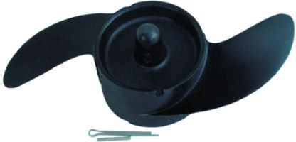
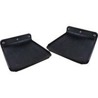
Navigator Replacement Power Prop Fits All Navigator Models - 481-658302 - 481-658302F1
Navigator Replacement Power Prop Propeller
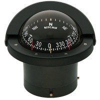
Navigator Compass, Flush Mt., Flat Dial, Black - Fn-201 - 128-Fn201F1
100% Repairable 4-1/2" dial with large numeralsBuilt-in compensators to easily adjust for deviationScientifically matched sapphire jewel and hardened steel pivot dial movementPowerful directiveforce magnets for fast heading lock-onMovable sun shield45° lubber linesExclusive 5 year warranty
Navigator Compass, Flush Mt., Combi Dial, Black - Fn203 - 128-Fn203F1
100% Repairable 4-1/2" dial with large numeralsBuilt-in compensators to easily adjust for deviationScientifically matched sapphire jewel and hardened steel pivot dial movementPowerful directiveforce magnets for fast heading lock-onMovable sun shield45° lubber linesExclusive 5 year warranty
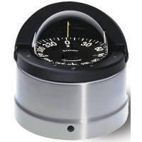
Navigator Compass, Deck/Binnacle Mount, Flat Dial, Polished Ss Finish - Dnp-200 - 128-Dnp200F1
100% Repairable 4-1/2" dial with large numeralsBuilt-in compensators to easily adjust for deviationScientifically matched sapphire jewel and hardened steel pivot dial movementPowerful directiveforce magnets for fast heading lock-onMovable sun shield45° lubber linesExclusive 5 year warranty
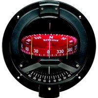
Navigator Compass, Bulkhead Mount, Combi Dial, Black - Bn-202 - 128-Bn202F1
100% Repairable4-1/2" Ritchie CombiDial and built-in inclinometerInternal gimbal systems for maximum stability during adverse pitch and roll conditionsScientifically matched sapphire jewel and hardened steel pivot dial movementBuilt-in compensators to easily adjust for deviation45 degree lubber linesExclusive built-in dual 12 volt NiteVu lightingFiberglass reinforced bowlExclusive 5 year warranty
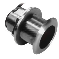
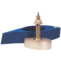
Navico XSONIC SS60 12° Tilted Element Thru Hull - 9-Pin Connector - 10M Cable
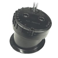
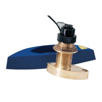
Navico B744V 50/200 kHz Smart xSonic 9-Pin TH w/Fairing Block
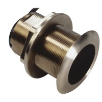
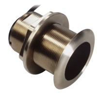
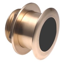
Navico B60 Thru Hull Transducer 12° Tilt, 9-Pin Xsonic Connector, Depth & Temperature
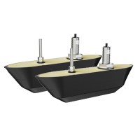
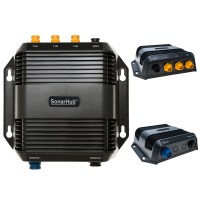
Navico Active Imaging HD 3-in-1 Fish Reveal (Dual) Thru Hull Transducers
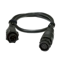
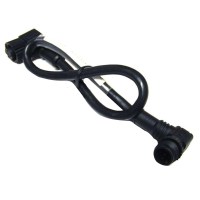
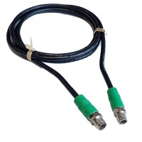
Navico 9-Pin Black to 7-Pin Blue Adapter Cable f/Non-CHIRP Transducers

Nauticus Hd800 Hydroplane Performance Trim Tabs - Hd800 - 338-Hd800F1
For Small Boats Under 16' (10 to 40 HP)Increase top speed with hydrodynamic lift. For overall stability, faster time to plane, and elimination of common problems like porpoising and chine walking, HydroPlane provides the port-to-starboard balance that hydrofoils cannot. Installs in Minutes.

Nauticus Ez48Wdb Ez Board Boarding Assist Handle, 48" - Ez 48-Wdb - 338-Ez48Wdbf1
Handle converts a fishing rod holder for use as a boarding assist handle which helps maintain balance while boarding. Slides easily into and out of most flush mounted rod holdersNo special tools neededMade from High Impact corrosion and UV resistant PVCFive (5) Year Replacement WarrantyMade in USA
Nauticus Ez36Wdb Ez Board Boarding Assist Handle, 36" - Ez 36-Wdb - 338-Ez36Wdbf1
Handle converts a fishing rod holder for use as a boarding assist handle which helps maintain balance while boarding. Slides easily into and out of most flush mounted rod holdersNo special tools neededMade from High Impact corrosion and UV resistant PVCFive (5) Year Replacement WarrantyMade in USA
Nauticus Ez24Wdb Ez Board 24" Kayak Handle - Ez 24-Wdb - 338-Ez24Wdbf1
Assist handle that attaches to the kayak easily, converts the standard fishing rod holder to provide stability when boarding. No special tools requiredMade from high-impact corrosion- and UV-resistant PVCAssist in maintaining balance while boardingSlides easily into and out of most flush mounted rod holders5 Year replacement warrantyMade in USA
Nauticus Ez22Wdb Ez Auxiliary Tie Down, 22" - Ez 22-Wdb - 338-Ez22Wdbf1
Acts as an auxiliary tie down, cleat or boarding handleAuxiliary Tie Down
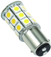
Nat Wht 1076 40-45K - 25006V - 672-25006Vf1
1076 base Tower LED Bulb. Applications include 12 or 24 VDC auto, marine, RV and military vehicles. High Power 5050 SMD LEDs. Beam Pattern 360 degrees.
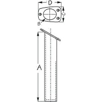
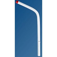
Narrow Gunnel Rod Holder, White - 325061-1 - 354-3250611F1
These Narrow Gunnel Flush Mount Rod Holders are constructed of injection molded ABS. Featuring a 30° angle they are designed for narrow gunnel applications while accommodating rods up to 1-5/8". Installs with three #10 FH fasteners (not included).
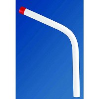
Narrow Gunnel Rod Holder, Black - 325060-1 - 354-3250601F1
These Narrow Gunnel Flush Mount Rod Holders are constructed of injection molded ABS. Featuring a 30° angle they are designed for narrow gunnel applications while accommodating rods up to 1-5/8". Installs with three #10 FH fasteners (not included).